
Showing posts with label maps. Show all posts

Sunday, September 5, 2010

Endless Blue - Week 36.5 - The Icht: The True First Ones

Archaeology


The Icht:  The True First Ones


Common wisdom tells that the Orcans are the oldest race, that their precursors, the Cetacean Barbarians, rose up first and formed the basis of society while the other races still swam mindlessly in schools.  But there is evidence to challenge this notion -- scant, dispersed, and teasing -- that there existed intelligence, fully formed and functional, when the pods of Cetaceans began their unification.  These rumors, forgotten memories of a time when life meant surviving until the dawn of the next day, tell a different story that the one the Orcan's lay claim to.  They speak of the ones before, the Ashamed, the great civilization known as the Icht Dominion.

The historians of the Cetacean Oceans vehemently deny any such culture, and decry those that espouse such nonsense as addled dreamers that cannot separate fact from fiction.  Where is the proof, they ask, where is the evidence?  Where are the ruined cities, the lost artifacts?  Where are the bodies?  No remains have ever been found, no bone or tooth, no art or text describing these enlightened predecessors of the civilized races.  What proof is there that these ancient pisceans even existed, save for the fevered imaginations of a small collection of disenfranchised conspiracists?

True, no tangible records exist of that time, an era in Elqua's history of primitive violence when writing had yet to be codified.  And no remnants of settlements can be found to attribute to the existence of the ancient pisceans.  But no relics?  No, the faithful responded, relics do exist...

The Icht did exist, pioneering a society that started in the rich valley known as the Creche of Civilization, stretched across the northern parts of the Periphery and the Hinterseas, with minor arms of influence reaching southwest.  Their influence is believed to have reached as far as the mountainous barrier called the Spine of the World, or even further beyond.

The extent of the Icht Dominion during the heyday of their reign.

Map of the territory in the Known World believed to be under the purview of the Icht Dominion during the heyday of their reign.
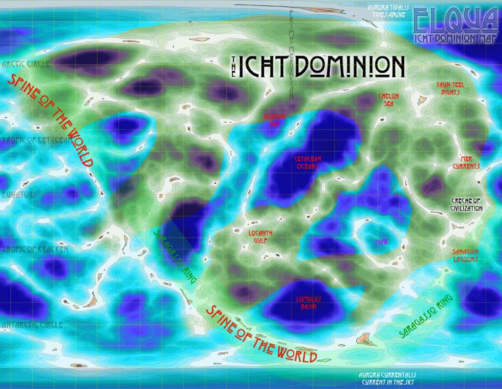
The area said to belong to the Icht is a wavy, inconsistent coverage of the Elquan seas.  There is a conspicuous avoidance of truly deep waters, as if during their expansionist movement certain areas of the world were anathematic for them.  Perhaps they could not survive the harsh conditions of life of the Shelf, or maybe it was locations themselves that repelled the Icht rule, but the Dominion surprisingly flows around these areas like an aquatic fungal ooze.

The Icht were indeed the earliest known society to flourish in the clear, bountiful seas of Elqua, a highly advanced culture easily surpassing their contemporary neighbors who where little more than the primitives pisceans treat the Ceph of today.  The society apparently disappeared abruptly under unknown circumstances. There is no evidence of natural phenomena doing them in, such as famine or catastrophic effect.  Word of mouth retelling, passed down so many generations that the veracity is on par with a child's dream, states that one day the Icht were plentiful, and the next...  It was if they willed themselves to no longer exist.

Some of the few relics credited to Icht creation are some highly ornate masks. Broad and hemispherical, these half-mask covered the upper portion of the face and  gave it a roundish look that swept forward into a two foot long point above the lip.  Rectangular holes for the eyes are widely spaced apart, suggesting the Icht had to tilt their heads in order to look at someone right in front of them.  The mask are constructed from a type of dark quarried stone rich with shiny flakes, then apparently hand-engraved with a pictographic trim and polished to a glossy texture.  The thickness and expansive coverage of the face suggests the race may have aesthetically reviled their own visages, and worn these masks to hide appearances that would normally offend.  Scratching and wear on the inside of the mask where the forehead rested against the stone makes it plausible that these masks were worn at all times an Icht walked in public.  This conjecture is further reinforced by discovery of small infant sized versions among those larger ones.

There seems to be a general consensus of how the Icht looked, despite there being no record of their appearance from which to infer.  Perhaps some racial memory, or simply due to repeated mythology, but a definite morphology has been detailed.  Severly hunched-backed, the Icht stood not even as tall as a Mer, yet were as thick as the fittest Orcan.  Like the Lumulus, they possessed a chitinous plating, but it only covered their forehead, face, and jaw.  A second plate of armor grew as a stiff collar around the neck, jutting upwards from the shoulders and hovering over their bent backs.  Tiny, beady pupils gleamed from beneath the armored forehead, with smaller bones circling around their eyes almost like a segmented Orcan dirham.  Their lower jaw was a mandible that not only moved up to mold against the palette, but pulled to each side as the jaw parted at the chin.  Those jaws had a form of teeth but no true dentin -- instead large bone edges like meat cleavers jutted from their gums.  Their hands were stunted and spindly, barely able to reach their own face, and their tails tapered off to a point instead of the furled fins and flukes that are part of the piscean form.  Their coloration is cited as muddy browns and pale olive, a drab camouflage pigmentation that may have helped to keep them hidden from notice did nothing for their attractiveness.

The Icht are credited by their supporters as being quite advanced technologically than even the current state of the Fluid Nations.  For a body of water so spread out, they must have mastered the arts of domestication and aquaculture in order to maintain the populace's need for food.  There is no proof of what kinds of tools they had at their disposal, but some of the more learned postulate that the Icht are the ones that erected the mysterious Spurs in the Bronze Epoch.  There is little to support this line of thought, but neither is there anything to disprove it.  And if the Icht are not the ones that created them, then what race did?

Thursday, February 4, 2010

Endless Blue - Week 06 - Map of the Known World

Oceanography


There is a plethora of intelligence beneath the waves of Elqua, and like any peoples, they group together with their neighbors and form communities.  Communities in the Endless Blue setting are defined by the body of water that holds the society, or “homesea”.  While they may seem to consist of a single species, immigration over the centuries has not left a single one without some level of intermixing.

On this water world, the nations formed due to geological formations and historical conflict, and thus are now clustered around a central area in the Eastern hemisphere.  With little knowledge of beyond its claustrophobic borders, this known world is broken down into three concentric divisions.

The Core

The Core is defined as the ruins of the Kraken Empire and the Crèche of Civilization.  Once populated, the area is now considered cursed and blessed (respectively), and much of the politics of the aquatic nations revolve around either coveting or despising the Core.
The main geographical feature of the Core is the Maw of the Kraken, the actual homesea of the once mighty Kraken Empire.  The borderseas around this area once belonged to other nations but was usurped during the Kraken Occupation.  Now, even long after the fall of the invaders, the area around the Maw is avoided at all costs.
The Crèche is treated as holy waters, and nearly every race wishes to claim it as their own.  It’ sea-beds are the richest in agricultural and mineralogical resources that, due to the contention between the races, remains nearly pristine from the era of the Icht Dominion.

The Periphery

The Periphery is comprised of the four civilized nations, which are clustered around the Core: the Cetacean Oceans, the Chelon Seas, the Lumulus Basin, and the Mer Currents.  These nations have relatively favorable conditions for harvesting crops and raising livestock, and as a result are the more affluent nations.

The Hinterseas

The Hinterseas are the area loosely made up of the nations of the primitive races: the Kouton Bay, the Locanth Gulf, the Sahaguin Lagoons, and the Yaun-Teel Bights.  They surround the Periphery, effectively corralling the civilized races inward towards the Core or each other’s territories.  At the more climatic extremes, these nations have poor natural resources to sustain their peoples, and thus results in unavoidable poaching on the wealthier nations’ borders.

Map of the Known World of the Endless Blue Campaign Setting


Bodies of Water
While nations maintain "no mer's seas" along their borders, this does not keep the natural encroachment of plants and animals across these imaginary lines.  With the primitive races that still maintain a nomadic lifestyle, following the herds on their instinctive migrations sometimes brings them into territorial conflicts with the indigenous denizens.

Cetacean Oceans
To the north and west of the Kraken’s Maw, the Cetacean Oceans are a deep double-impact crater that is claimed to include the deepest point on all of Elqua.  It is an expansive, fathomless place well suited for the Orcan race.  The phytoplankton (the lowest link of the food chain for the entire world) in this area is plentiful and varied, enabling the Orcan peoples to turn inward into the craters in their quest for new feeding grounds.  It is perhaps the best balanced area, with sufficient Shore, Shoal, and Shelf areas to keep the nation nearly autonomous and independent of imports from the other nations.

Chelon Sea
The Chelon Sea is nearly completely comprised of Shoals, a rolling sea-bed of rich silt and vital sediments.  Its gentle, dependable currents keep the sea temperate even at its most northern places.  Flora and fauna of the Chelon Sea is perhaps the most varied, if not the most beautiful, in all the world of Elqua.  It is referred to by its people as nature’s utopia, where the inhabitants live in harmony with the surroundings.  Here, amid the placid beauty, lies the Abyss, a sheer vertical drop in a vast plains area of the Shoals zone that stretches for miles.

Kouton Bay
To the north and west of the Cetacean Ocean, the Kouton Bay arcs around the Orcan homesea from the Locanth Gulf to the Yaun-Teel Bights.  It’s deep, cold currents are rife with wildlife.  The Bay of Kouton is the spawning waters for many of the main fish species that make up the diet of the civilized and primitive races alike.

Locanth Gulf
The Gulf of Locanth is the central populated area of the Locanth Gulf, and reaches northward to the Kouton Bay and southward to the Lumulus Basin.  The most westward of the aquatic nations, it is here that the plant ricelqua was discovered, where it grows more prevalent than seaweed.

Lumulus Basin
The deep, concave basin populated by the Lumulus is riddled with thermal vents that become more and more frequent the further south traveled towards a particularly volcanic portion of the Spine of the World.  With such little Shore and Shoal zones, agricultural imports are vitally important to support the Lumulite population.  It is the only civilized nation that has an outer border not blocked by one of the primitive races, butting out between the Bay of Kouton and the Gulf of Locanth.

Mer Currents
Perhaps the most densely populated waters on Elqua, the various Currents of Mer are loosely banded together as a single nation.  Bordering on the Crèche of Civilization, the Mer Currents benefit from species migration out of the untouched holy sea, and has allowed its tribes (each a “current” in the nation’s name) to explode with unparalleled success.


Sahaguin Lagoons
Located between the Crèche of Civilization and the southern ice cap, the Sahaguin Lagoons border on the ruins of the Kraken Empire and the Mer Currents.  It follows the Shade of the Sargasso Ring – the area wrapping around the globe of Elqua where the planet’s green rings cast an emerald twilight – quite closely.  It is comprised of a string of lagoons and other Shoal-level areas randomly dotted along the islands in that area.  At its south-most point it is suddenly truncated by the frozen barricade that is the southern polar ice-cap.

Yaun-Teel Bights
The Yaun-Teel Bights neighbor the Chelon Sea and the Mer Currents to the north, and dip down towards the Sahaguin Lagoons to the east.  Essentially barren due to the misuse at the hands of its own inhabitants, the Yaun-Teel resort to heavy raiding of the Chelon and Mer territories to sustain themselves.

What lies beyond the known world is a mystery.  Until now, there has been plenty of room for the races of Elqua to grow and develop.  A few – the brave, the ostracized, the insane – have traveled the seas beyond, but only tales and supposition remain as to what final fate awaited them.

Thursday, January 28, 2010

Endless Blue - Week 05 - Elqua

Oceanography

Deceptively tranquil, the wide blue swaths of Elqua’s oceans belie a complex geographical system beneath the surface of the Endless Blue setting's water world.

Mollweide projection of Elqua

This holomographic view (Mollweide projection) shows the scattered links of island chains on Elqua and areas of the Shore around them in cyan, a rough approximation of the Shoals in light blue, and the Shelf in deep dark blue. The intelligent races of the Endless Blue setting straddle these zones in a precarious attempt to not encroach on other’s territory, but still need their own room to grow. This tangled web-work of sub-aquatic sandbars and islands make the division of living space somewhat hazardous and quite complex.

The major geographical feature that can be seen is known as the Spine of the World, a series of mountain tops peaking out of the seas, forming several island archipelagos in an almost complete circle around the globe. Despite the continental drift of the eight major tectonic plates (and four minor), these chains of tiny islands are still roughly synchronous with the world’s planetary ring, fating these areas to an ever-present semi-green dusk known as the Sargasso Ring. This shadow does move slowly with the passage of time, but a clearly identifiable range has been determined by the natives, who live accordingly.

The arctic and Antarctic circles are defined by the 30° longitude (or represented with the sigil λ) from each pole. These mark the circle around Elqua where the sun begins to stay above or below the horizon for a full 24 hours. The southern circle is dominated by a massive polar icecap. A humongous permafrost monolith that nearly fills the Antarctic Circle, it is a solid slab of ice from surface to ocean floor, and acts like a barrier along the borders of the southern nations, preventing migration in that direction. Its northern parallel lacks a similar sheet of ice, but does have one of the world’s largest land masses nearly at the magnetic pole – an islet with an tapering peninsula pointing eerily, almost accusingly, toward the north pole…

At about 9° λ each are Elqua’s breath-taking aurorea, made much the more spectacular due to the high levels of noble gases in Elqua’s atmosphere that fluoresce greatly as the ionized oxygen and nitrogen in the upper atmosphere give off light, and can easily be seen from beneath the shallow waters of the Shore. The wavy, cascading undulation of the aurorae have been likened to gossamer seas overhead, and have been dubbed The Tides Above and The Currents in the Sky for the north and south poles, respectively. It is one of the few phenomena from above the waves that possess anything close to a positive association, in the face of the hellish damnation that Elquan religions have reinforced in the populace.

The tropics of Cetacean and Kraken lie at approximately 64° λ. The Tropic of Cetacean is the line of longitude that circles the globe at the northernmost point where the sun is still directly overhead at noon, usually on the summer solstice. Conversely, the Tropic of Kraken is the southernmost point on the winter solstice. The area between these two circles is the tropics, and serves as the best place for horticultural harvesting. Both longitudes are named after the nations that are bisected by the lines of longitude.

The Prime Meridian is defined as the line of latitude (signified with a symbol φ) that runs over the deepest known point on Elqua, in the Cetacean Ocean. It was chosen arbitrarily (some would say disparagingly) by the Chelon, whom are credited with the creation of the geographic coordinate system. Modern cartographers argue that the point in question is hardly the deepest point on the ocean floor, giving the Abyss in the Chelon’s own sea as just one example. Despite this, Chelonian oceanographers remain steadfast in their reason and shut-mouthed in the face of contrary evidence, and the Orcan resolutely refuse to allow any outsider that far into their borders.  Along with the 180th latitude, the prime meridian forms the boundary between the western and eastern hemisphere.

Topographic map of Elqua

Continents
Unlike our world, where the ocean’s edge helps form the shape of continents, Elqua’s tectonic plates are more eroded from constant ocean currents. To complicate this, sometime in the world’s past the planet was bombarded by meteoric activity, as evidenced by the plentiful number of crater basins forming the deepest depths of the world. Most likely the planet was impacted by multiple comets of massive size, fracturing in the unique atmosphere and filling the planet with its immense oceans with water. As a consequence, the national borders of Elqua’s countries are defined more loosely than those of our own. “No Mer’s Waters” exist between nations, serving as both buffer zones between expanding populaces and also as a kind of national park, where wildlife has ample opportunity to refresh its numbers from the predations of homo Pisceans.

Crèche of Civilization
One specific crater is of special significance to the denizens of Elqua. It is called the Crèche of Civilization, so named as the intelligent races trace back their history to this relatively shallow but wide basin as the birth place of Piscean life. It is here it is believed that the now-extinct Icth originally rose to prominence, and most every race calls it their mother sea.

Maw of the Kraken
A ring of islands formed by a crater that once delineated the Kraken homewaters, the Maw looks like the distended, wide-open jaws of a gargantuan megalodon breaking the surface to feed. While most of the occupied seas were reclaimed when the Kraken Empire fell, the waters inside the Maw are still avoided at all costs as it is believed that much of the Kraken’s foul magics still permeate the ruins.

Migrating Islands
One of the strangest geological formations on Elqua is the rare, solitary floating islets. While most islands are either formed by volcanic eruption or tectonic pressure pushing the seabed to the surface, there are a handful of large islands that are not anchored into the sea floor. Like icebergs made of rock and dirt instead of ice and snow, these islands float slowly on the waves of the myriad seas independent of tectonic plates and continental drift. Just like icebergs, the larger volume of these floating landmasses bobs beneath the surface, just as clustered with wildlife as any reef or shoreline.

Tectonic plates of Elqua