
Deceptively tranquil, the wide blue swaths of Elqua’s oceans belie a complex geographical system beneath the surface of the Endless Blue setting's water world.
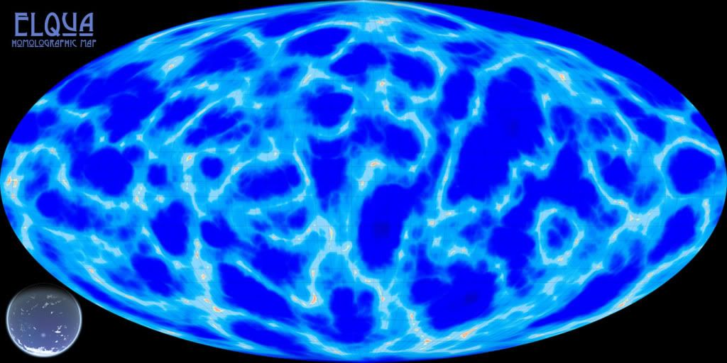
This holomographic view (Mollweide projection) shows the scattered links of island chains on Elqua and areas of the Shore around them in cyan, a rough approximation of the Shoals in light blue, and the Shelf in deep dark blue. The intelligent races of the Endless Blue setting straddle these zones in a precarious attempt to not encroach on other’s territory, but still need their own room to grow. This tangled web-work of sub-aquatic sandbars and islands make the division of living space somewhat hazardous and quite complex.
The major geographical feature that can be seen is known as the Spine of the World, a series of mountain tops peaking out of the seas, forming several island archipelagos in an almost complete circle around the globe. Despite the continental drift of the eight major tectonic plates (and four minor), these chains of tiny islands are still roughly synchronous with the world’s planetary ring, fating these areas to an ever-present semi-green dusk known as the Sargasso Ring. This shadow does move slowly with the passage of time, but a clearly identifiable range has been determined by the natives, who live accordingly.
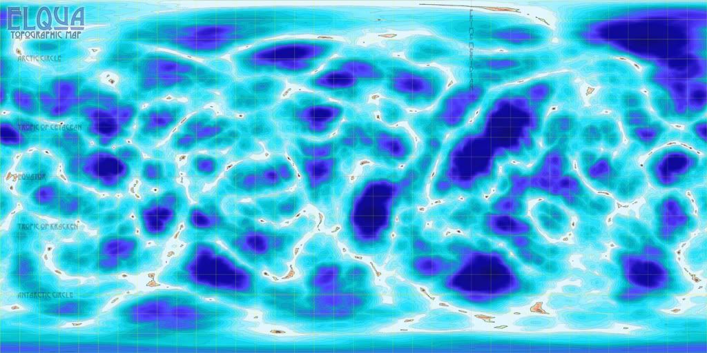
The arctic and Antarctic circles are defined by the 30° longitude (or represented with the sigil λ) from each pole. These mark the circle around Elqua where the sun begins to stay above or below the horizon for a full 24 hours. The southern circle is dominated by a massive polar icecap. A humongous permafrost monolith that nearly fills the Antarctic Circle, it is a solid slab of ice from surface to ocean floor, and acts like a barrier along the borders of the southern nations, preventing migration in that direction. Its northern parallel lacks a similar sheet of ice, but does have one of the world’s largest land masses nearly at the magnetic pole – an islet with an tapering peninsula pointing eerily, almost accusingly, toward the north pole…
At about 9° λ each are Elqua’s breath-taking aurorea, made much the more spectacular due to the high levels of noble gases in Elqua’s atmosphere that fluoresce greatly as the ionized oxygen and nitrogen in the upper atmosphere give off light, and can easily be seen from beneath the shallow waters of the Shore. The wavy, cascading undulation of the aurorae have been likened to gossamer seas overhead, and have been dubbed The Tides Above and The Currents in the Sky for the north and south poles, respectively. It is one of the few phenomena from above the waves that possess anything close to a positive association, in the face of the hellish damnation that Elquan religions have reinforced in the populace.
The tropics of Cetacean and Kraken lie at approximately 64° λ. The Tropic of Cetacean is the line of longitude that circles the globe at the northernmost point where the sun is still directly overhead at noon, usually on the summer solstice. Conversely, the Tropic of Kraken is the southernmost point on the winter solstice. The area between these two circles is the tropics, and serves as the best place for horticultural harvesting. Both longitudes are named after the nations that are bisected by the lines of longitude.
The Prime Meridian is defined as the line of latitude (signified with a symbol φ) that runs over the deepest known point on Elqua, in the Cetacean Ocean. It was chosen arbitrarily (some would say disparagingly) by the Chelon, whom are credited with the creation of the geographic coordinate system. Modern cartographers argue that the point in question is hardly the deepest point on the ocean floor, giving the Abyss in the Chelon’s own sea as just one example. Despite this, Chelonian oceanographers remain steadfast in their reason and shut-mouthed in the face of contrary evidence, and the Orcan resolutely refuse to allow any outsider that far into their borders. Along with the 180th latitude, the prime meridian forms the boundary between the western and eastern hemisphere.
Continents
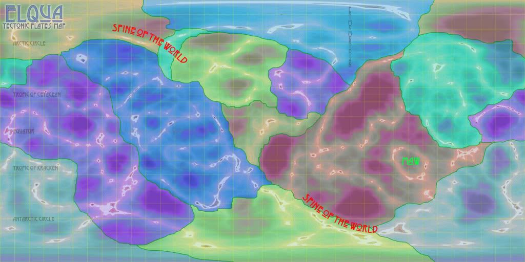
Unlike our world, where the ocean’s edge helps form the shape of continents, Elqua’s tectonic plates are more eroded from constant ocean currents. To complicate this, sometime in the world’s past the planet was bombarded by meteoric activity, as evidenced by the plentiful number of crater basins forming the deepest depths of the world. Most likely the planet was impacted by multiple comets of massive size, fracturing in the unique atmosphere and filling the planet with its immense oceans with water. As a consequence, the national borders of Elqua’s countries are defined more loosely than those of our own. “No Mer’s Waters” exist between nations, serving as both buffer zones between expanding populaces and also as a kind of national park, where wildlife has ample opportunity to refresh its numbers from the predations of homo Pisceans.
Crèche of Civilization
One specific crater is of special significance to the denizens of Elqua. It is called the Crèche of Civilization, so named as the intelligent races trace back their history to this relatively shallow but wide basin as the birth place of Piscean life. It is here it is believed that the now-extinct Icth originally rose to prominence, and most every race calls it their mother sea.
Maw of the Kraken
A ring of islands formed by a crater that once delineated the Kraken homewaters, the Maw looks like the distended, wide-open jaws of a gargantuan megalodon breaking the surface to feed. While most of the occupied seas were reclaimed when the Kraken Empire fell, the waters inside the Maw are still avoided at all costs as it is believed that much of the Kraken’s foul magics still permeate the ruins.
Migrating Islands
One of the strangest geological formations on Elqua is the rare, solitary floating islets. While most islands are either formed by volcanic eruption or tectonic pressure pushing the seabed to the surface, there are a handful of large islands that are not anchored into the sea floor. Like icebergs made of rock and dirt instead of ice and snow, these islands float slowly on the waves of the myriad seas independent of tectonic plates and continental drift. Just like icebergs, the larger volume of these floating landmasses bobs beneath the surface, just as clustered with wildlife as any reef or shoreline.


No comments:
Post a Comment